-modified.png)
The high Tatras hike that made us cry of pain and joy
- Leon

- Apr 1, 2022
- 14 min read
Updated: Apr 1, 2025
Have you ever started a hike but discovered you are not prepared for it?
We did! What happened? Did we plan poorly? Were we unlucky? Did we think that we can just get off the couch and do it? Maybe all of the above?

This hike that we did, is totally doable (we have proof, we did it!). Read through the adventure that we had, take notes in case you are planning anything similar, or just see what we've learned from doing it, but most of all enjoy!
The hike
The stats:
63km | 6 days | Max alt: 2473m | Min alt: 849m | Ascent: 3452m | Descent: 3932m
The route:
First things first, a disclaimer. This was not the original plan but the actual hike we managed to do. The original plan include A LOT more walking, you'll read below about what, how and why we changed our plan on the go. All the names of the places are written in the local language, and all the photos were taken by us.
Let's start the hike!
Day 1 - From point 1 to point 2 | 5km | 2hr
The story
We had our equipment ready and packed:
65L, 20kg backpack (for me)
40L, 15kg backpack (for Lucy)
2 people, 3 season tent
2 sleeping bags
Cooking equipment
Food
Water
Clothes
To get to our starting point, we took a train from Bratislava to a small town that's called Štrba, there we went a (very old) tram that took us up to Štrbské Pleso, the starting point of our hike. We explored the town a bit (and a very picturesque lake) and from there we walked about 5km (2hrs) on a quite easy walking path until we arrived to Popradské Pleso (point 2 on the map). We stayed in the mountain hut there and took the evening to soak in the already beautiful surroundings, we have found a climber's cemetery and another lake. I'll add some photos here so you will not miss out.


We cooked our own dinner with our equipment, and that was all for the first day. We wanted to start slowly, no rush, and no tiredness before the hardest day planned
Day 2 - From point 2 to point 4 | 10.5km | 10hr
If you are following the map, this day takes us from Popradské Pleso (Start point) through the highest peak in Poland (point number 3) to Morskie Oko (point number 4) where we spent the night.
Us being us, we woke up around 9:00. The rest of our roommates woke up around 4:00 and left climbing mountains as the usual way to do in these places. We had a nice breakfast and our original plan was to hike both Kôprovský štít (2363m) and Rysy (2503m) peaks on this day. Lucky for us, this crazy idea went down the drain very fast once we realized that it would just take too long, being almost midday when we started hiking, we decided to save the 10km it would take us to to hike only Rysy. The way up was not too bad, especially because we enjoyed the fact that there were not too many people, being the beginning of the COVID-19 pandemic (well, the end of the first lockdown to be more exact). On a normal day in high season the Slovak side of peak, which is a long but friendly hike even for children, the mountain is so full that the people form a long standing line to get to the top (or at least to the mountain hut below the peak. Don't believe me? Search it on YouTube. We still had dozens of people hiking with us, but it was more like light traffic in a village than rush hour in New York. The walk up to the mountain hut (Chata pod Rysmi) was pretty straightforward, about 5km, 3 hours of walk, and a well deserved beer break.

The hut is the point of return for most of the visitors, they have their beer and just hike back to Popradské Pleso, the starting point. From here on the hike is already steeper and colder. The ones that keep going make their way to the peak 1km away in around half an hour.

We had other plans, we stopped for another beer break on the scenic viewpoint Váha on the way (hey, it had a natural cooling system for the beer, we couldn't hold ourselves).
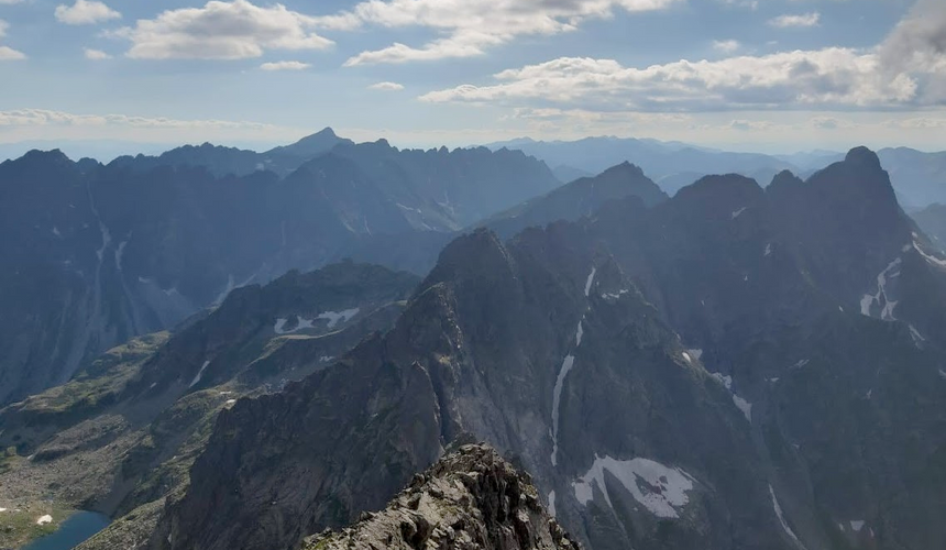
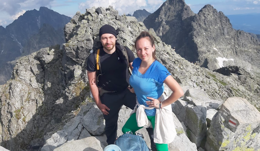
After finishing another long break, we continued, finally arriving to the peak, sharing it with the 15-20 people left. On the peak you will meet an amazing view!
First of all, this peak is a border pas between Slovakia an Poland, and Poland's highest peak at that, meaning that you can see the many peaks and lakes around. Just amazing!
We hung around the top for some time, up until Lucy's fear of heights started to kick in. The time was around 17:00, the map showed about 5km to our sleeping place and that we should complete it in about 3.5 hours. We figured out that if we start now we'll finish the day around 20:30 and decided to start our descend.


On this point, most of the people are going back down to the Slovak side, and outside of us two, there were only two people we me on the Polish side of the mountain.
The thing that we didn't know, is that the Polish side of the mountain is a lot harder to hike. Starting with some places that you have to hold a chain to get up or down for safety, continuing with a very rocky path a decline that is much steeper. We started to understand that it will take us a lot more than 3.5 hours so we tried to hurry up. After something like an hour, Lucy's leg started hurting so we stopped for a break, and continued once we saw the sun is starting to set over the mountain.
Funny story here, that day was my mom's birthday. Me being stupid, I forgot to call her before we started the hike, and remembered it just during the descend. Weirdly, we've found a spot that I had some reception on my phone and I video called my mom with the mountain in the background to wish her a happy birthday.
Back to the hike, the problem was that Lucy's leg did not rest properly, and her pain just increased with every step she took. We kept walking down, until a point Lucy felt she couldn't walk anymore. We decided to take a long break. We sat for about half an hour and had a snack, when we thought of continuing (with the goal of reaching before darkness), Lucy was still in pain. The only logical thing we could think of is to decrease her weight, so I took both backpacks on me. We kept walking very slowly and reached down just when the sun was about to go down completely. The problem? We still have an hour and a half to go (all this suffering was only about half of the way... Can you imagine?). At least the way was completely flat. At the bottom of the mountain there are two lakes, we managed to go around the first one before the darkness came, both of us were exhausted. At that point, between the two lakes, we saw some people building up their tents, but me being the stubborn person that I am, I had to finish what we planned for that day. We walked for half an hour more and arrived to the mountain hut at the end of Morskie Oko, the second lake. The time was around 22:30, and lucky for us they still had free beds.

The accomplishments of the day: One mountain peak, 10.5km distance, around 10 hours with a lot of breaks, sore bodies and minds, but proud and happy that we made it
Day 3 - From point 4 to point 7 | 22km | 10hr
We slept like dead, woke up around 10:00, to this view:

Worth every drop of suffering from the previous day! I mean, we were up there, in the misty part!
The plan for the day was to get from Morskie Oko (point 4) back to the Slovak border (point 6) to a camp site that's called Táborisko na poľane pod Vysokou (point 7) and call it a day. The day is easy, especially compared to the previous one, at least it supposed to be. If you are looking at the map, you can see a flat road that is going from Morskie Oko straight to the border, about 10km, about 2.5 hours of walking.
As we started to walk, around 11:00, we didn't even manage to walk far enough to not see the hut, we see a person that works in the national park. She nicely tells us that today (of all days in life) the road is closed for renovations and we have to walk around. We looked on the map and saw that the only way around is to go up another (smaller) mountain (point 5). The road to the border just became a 13km, 6 hours walk. Whatever healed from our legs during the night regressed in that second, we are hiking another peak (because we are definitely not going back to Rysy).
The walk around was still easier than Rysy, but we still did not expected that so it took another toll on our soreness and tiredness. At least the views are nothing to complain about.

Point 5 is a touristic hut with a restaurant and a lot of places to sit around. It is easily reachable (not from where we came from though), so it is frequently visited and had a lot of visitors even during COVID-19. We rested there, had our daily dose of beer and continued. The road to the border was uneventful, we even managed to hitchhike the last 3km with nice people that probably saw us, the only people going down that mountain with backpacks, suffering and decided to pick us up.
The border crossing point is called Lysá Poľana (point 6) and has a shop and a fast food place, we got whatever we thought we are missing and kept going towards the camp site, 9km, around 3 hours walking. The way was more of the same, kind of flat, already a more foresty area. Somewhere along the way there is a hut where the guardian of the national park lives, you should stop there and pay the funny 5EUR entrance fee per person (I mean, he protects you from bears, I think he deserves it).
We arrived to the camping in the dark, around 21:00, built our tent and went to sleep after introducing ourselves to the other hikers and their dogs (they barked at us so we wanted to become their friends).

The accomplishments of the day: One (small) mountain peak, 22km distance, around 10 hours with a lot of breaks, still sore, still exhausted, but the next day should be shorter
Day 4 - From point 7 to point 9 | 7km | 6.5hr
We woke up at, get ready, 13:00. At this time other people are already finishing their day and we haven't even started. The worst part? It was raining at night and we didn't think it through and put all of our clothes against the walls of the tent. The result? All of our clothes are wet. We tried to get a fire going in the camp's fireplace but without success. We managed to salvage just enough dry clothes to be dressed enough to keep going. The goal of today is to get from the campsite (point 7) to Sliezsky Dom mountain hotel (point 9), through another peak called Poľský hrebeň, 2200m (point 8). The map says 7km, a bit more than 3 hours. We start walking at around 15:00, thinking that we should arrive to our destination at around 18:00 and call it a day, easy enough.
The day is misty, but the views keep us entertained.

We are still exhausted from our last two days, walking a lot slower than the map is suggesting. After an hour and a half, we're not even halfway to the peak. Lucy felt better on this day, we slept a lot and rested, on the other hand this is also the day when I lost it, my body finally told me what Lucy's told her on the way down from Rysy two days before. Enough is enough! As we were ascending the mountain I just hoped that the peak is around the next rock that I can't see behind, but it wasn't. It wasn't around any of the 50 rocks we passed, and after each rock I just became more exhausted and more discouraged. Finally, we arrived to a place from which I can see the peak. It was a frozen lake, and we had to go around it and Lucy's fear of heights was kicking in again.

We saw some people coming down from one of the higher peaks nearby and I felt a slight relief that we're not the only ones on the mountain. The other people were probably doing a day trip, they had way less equipment than us and moved a lot faster. After a lot of suffering (mainly mine this time) we arrived to Poľský hrebeň. Half way there.

The time was around 18:30, that was the time we were supposed to finish the hike for today, you can see how happy I was in that photo! The good news were that I could see the hotel from the top of the mountain, if I see it I can reach it. We started descending, the first part is a hard one, there are chains to hold on to but they are cold and our hands are freezing. We managed to do it slowly, and the rest of the way was walking down, not to steep but took time. At around 21:00, at the dark again, we arrived to the hotel. It was cold outside and we were extremely tired so we decided to get a room in the hotel. We asked at the reception, and the hotel was fully booked! The only room available was the presidential suite, that costs for one night more than we paid for the whole trip. We declined politely, and decided to sleep in a tent somewhere outside after we eat a dinner in the hotel.
During the dinner the person from the reception came to us and told us that if we want we can sleep in the lobby so we won't have to sleep in the cold, the downside was that it is a mountain hotel and the guests start going out around 5:00 to go climb the mountains around. We didn't care, it was warmer and more comfortable than sleeping in the tent in the cold.
The accomplishments of the day: Yet another mountain peak, 7km distance, around 6.5 hours of walking, wondering whether we have a mental problem that we decided to go for this trip.
Day 5 - From point 9 to point 10 | 6km | 3hr
As promised, people started going out around 5:00 and we woke up. We managed to try to sleep until 7:00 and then decided to get up. We ate breakfast at the hotel and went out. After our route over the last three days, we figured out that there is no point estimating times and distances, so we just decided to keep going until we don't feel like going anymore. The day was foggy again, but a foggy forest never disappoints.

We ended up walking 6km up until a village called Hrebienok, where we stopped for lunch. After lunch we decided to keep walking. That lasted exactly 5 minutes, at Bilíkova chata (point 10). It is another mountain hut, with rooms to rent for the night. It was around noon, and we walked around 3 hours so far. We liked the place, and they even had a sauna! We looked at each other and just decided that we walked enough for today and we are staying for the night. Oh and what a good decision it was... We rested up during the day, and had an hour at a sauna with a huge window looking at the mountain peaks around. My only regret is that I didn't take a picture of it, so you will have to believe me that it was one of the biggest highlights for us.
The accomplishments of the day: No peaks! 6km distance, 3 hours of walking, rest, sauna, amazing views.
Day 6 - From point 10 to point 13 | 6km | 3hr
We woke up rested, our original plan was to keep walking until Ždiar, but as we almost didn't walk anything the day before, we had a lot to catch up. 24km, more than 10 hours of walking. We decided not to do it to ourselves. We walked for about 3 hours, until we reached a place called Skalnaté pleso (point 12). The fog was heavy that day, but from time to time, depending on our angle we could see some rays of sun, there was a waterfall on the way (point 11) and the forest surrounding our hike was looking good as usual.

When we reached Skalnaté pleso, we had the option to take the cable car up to Lomnický štít (2634m). They have a few viewpoints and an observatory that on a good day observes the whole area. This, was not one of the good days.

Having the feeling that the higher we go the more foggy it will get, we decided to just go down to the nearest town and wait for a bus. The way to Tatranská Lomnica (Finish point) took us around 2 hours, and was 6km long. We walked down a path that in the winters is serving as a ski slope, some of it was steep, the other part less. We did not suffer much as we were rested and our backpacks weighted a lot less than when we started. We arrived to the bus station in the town and took a bus to Ždiar, finishingthe hiking part of the trip.
The accomplishments of the day: 6km distance, 3 hours of walking, giving in to the fog, finishing the most demanding hike we ever did.
Days 7-8
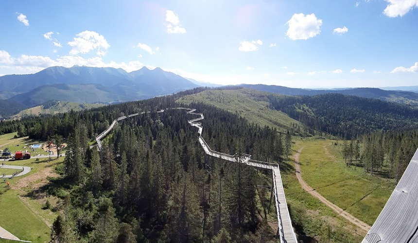
Ždiar is a very picturesque village. We ended our trip there, staying for a few days in a family home. On one of the days we walked around to a place with a high tree walking route (and a scary high slide), it took about 2 hours each way, but we hardly felt it as we left the equipment in the apartment and only took a bottle of water with us. The village itself has a lot of good food to offer and a general chill feeling that we embraced after our adventure.


Conclusions
We suffered a lot during these days, especially in the beginning. For us looking back it was worth it as we re-tell the story you read here over and over again. On the other hand, we both know we wouldn't do it again and we will be planning a lot differently the next time we are in high Tatras.
In retrospective, these are the main things we took from it
What went right? | What went wrong? |
We were flexible - We made our changes mid-hike and saved ourselves from suffering even more | We overestimated our physical condition - To think that we wanted to add another peak on day 2, and 24km more walking on the last days... |
We did not push it unless we had to - When we had the chance we did not pile on our tiredness and chose to rest instead | We were too heavy - Having a total of 35kg of equipment definitely harmed us, especially when we were carrying food we didn't need, cooking equipment that we used only on the first night because we felt we have to, and some other unnecessary items |
We have been prepared - Our tent was good, our backpacks were comfortable, our shoes were comfortable. Just imagine how much worse everything would have gotten if we also had to worry about these things. | We started hiking too late - Had we started our day 2-3 hours earlier each day, we wouldn't be arriving in the dark. It would stress (at least) me out a lot less, and we could take more breaks without being in a hurry |
We made it, and looking back, we enjoyed - that's the whole point is it not? | We didn't know the terrain - We just assumed that if the map says it is walk-able then it is. Without taking into account that it will not be so easy, and that we would be much slower with everything we carry |
Final thoughts
We hope you liked our story, and we hope you learned from it. Do not be afraid to try to hike parts of this route, or even the whole thing, just plan a bit better than we did.
Our advice for hiking in High Tatras would be taking way less equipment, and rely on what the area has to offer. Next time we are skipping the camping part, bringing only small backpacks with some clothes and water. Planning to sleep in the huts and plan day hikes a bit more efficiently.
Was this story helpful? Did you enjoy it? Tell us, or spread the word!
Until next time!


Comments